Never walk home alone again with Companion app and Google Maps
Editor’s note: This is the second post in our “Mapping a Better World” series, highlighting organizations using location data to affect positive local and global change. Today’s guest post comes from Jake Wayne, co-founder of Companion, a safety app created so no one has to walk home alone. The company was founded by five University of Michigan students.
Making sure friends and family get home safe, especially late at night, is a common concern, but a text message confirmation can be unreliable since people often forget to send the message or check that the other person arrived safely. Some colleges have taken safety precautions by introducing escort systems in which police officers walk students home, but outside of these institutions there wasn’t an automated system in place to help people feel safe and connected if they’re walking or driving home alone.
When we learned that fellow University of Michigan students felt unsafe walking or driving home late at night, we decided to create a way for people to let family, friends or the public safety department know they’re headed home and give them a tool to quickly contact others if they feel unsafe. Younger generations have grown up with mobile phones, so it’s natural for them to reach for their phones in times of need. That’s why we created Companion, because human safety is an issue beyond college campuses.
When we set out to create the app, we knew we wanted to build something that ultimately improves the way we live. In just three months, we created an app that now more than one million people in 184 countries have interacted with — both as users and companions. We’re excited to continue making an impact.
When it comes to safety, everything needs to work seamlessly. We decided to use Google Maps for our app, because consumers and developers alike trust Google Maps technology. Google Maps is easy to use and available internationally. When users open the Companion app and see Google Maps, it gives them peace of mind due to its familiar user interface.
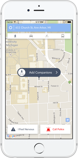
When a user requests a friend to accompany them as a “companion” on the walk home, the app tracks the person walking home on a map in the app. Companions don’t even need to have the app downloaded to make sure the user get home safely. The user can reach out to their companion to let them know they feels nervous with one tap on their phone, prompting the companion to check in. With two taps, the user can dial 911.
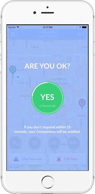
If the app detects a sudden change, like the user running or removing headphones, the app sends a notification to the user asking if they’re OK. If there’s no response within 15 seconds, the app notifies the companion, who can instantly contact the police from the app. The app will also make siren noises and go into alert mode, until the user is confirmed safe.
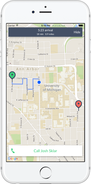
The Google Maps Places API makes it incredibly easy for users to input their destinations quickly and accurately. Google Maps also considers travel history when users have their location history turned on to help make travel time estimates more accurate. Using the Directions API, we’re able to better estimate how long it will take a user to get from Point A to Point B, and communicate this to their companions every step of the way.
The Companion app also collects anonymous information about locations where users feel nervous. This allows us to analyze the data and share it with the safety officials and universities to help make streets safer. For example, we’re working with the University of Michigan police department to help determine areas that should be patrolled.
When you’re dealing with safety, user trust and confidence is important. Google Maps APIs helps our users feel that Companion can facilitate a safe journey home.